Research Memo: Identifying Pasture with Trees in Satellite Imagery
- Water Production Connections
- Aug 21, 2020
- 2 min read
Updated: Apr 20, 2021
By Cassie Sevigny and Trent Biggs
The Connections between Water and Rural Production project (CAP) investigates whether and which farmers adapt their production systems when they experience changes in rainfall, what adaptations they make, and whether these adaptations reduce income losses expected when drying occurs. Improved understanding of these responses will inform efforts by government agencies and civil society to help farmers adjust to changes in water availability. This research memo describes a new way to assess land cover using satellite imagery.
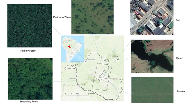
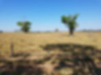
Research Question: How well can we tell apart pastures with no woody vegetation ("clean” pasture) from those with shrubs and trees ("dirty" pasture) when using remote sensing data?
Researchers use satellite imagery to measure pasture health, as indicated by the level of vegetation greenness. Greener pasture indicates healthier pasture, but shrubs and trees (which are often green all year) can make pastures seem greener. This is particularly problematic in the dry season or during droughts when grass has low greenness. Most maps don't distinguish between plain pasture ("clean pasture") and pasture with trees and woody plants ("dirty pasture"), which could result in the overestimation of pasture health. Masters student Ye Mu, hydrologist/geographer Trent Biggs, geographer Doug Stow (all from San Diego State University), and remote sensing specialist Izaya Numata from South Dakota State University developed a method for making this distinction.
Mu et al. were able to use a new imaging index that notes the amount of variation in the kinds of light reflected within a 30 square meter piece of land (a "pixel"), which allowed them to categorize each pixel as pasture with trees/shrubs and pasture without trees. The researchers generated a map of the land cover revealed by the satellite imagery with the new categorization and found more pasture with trees than anticipated, suggesting that about half of all pastures have some sort of woody plants. This implies that woody pastures are common enough to noticeably affect pasture health measures if they are not excluded from greenness analyses. Widespread woody vegetation also suggests more pastures may hold higher amounts of carbon than previously expected.
Ye Mu, Trent Biggs, Douglas Stow & Izaya Numata (2020). Mapping heterogeneous forest-pasture mosaics in the Brazilian Amazon using a spectral vegetation variability index, band transformations and random forest classification. International Journal of Remote Sensing, 41:22, 8682-8692. DOI: 10.1080/2150704X.2020.1802529